Landslide Area Prediction using Machine Learning and Unmanned Aerial Vehicle (UAV) Imaging
Description
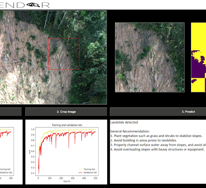
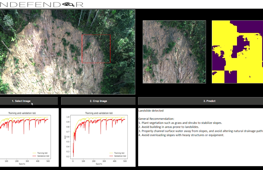
Landslides are a common natural hazard that poses significant risks to infrastructure, communities, and the environment. Our technology/work aims to provide an early warning system for potential landslides, enabling stakeholders to take proactive measures to prevent or mitigate the risks. By using machine learning algorithms, our technology/work can analyze terrain data and identify areas at high risk of landslides with a high degree of accuracy. This information can be used to develop landslide risk maps, inform land use planning, and guide infrastructure development. We also leverage the capabilities of UAV imaging to capture high-resolution imagery of terrain data, allowing for a detailed analysis of slope stability and other factors that can contribute to landslide hazards. Our technology/work can process this data in real-time, providing timely information to stakeholders and enabling them to make informed decisions. The potential applications of our technology/work include infrastructure development, land use planning, disaster prevention and management, and environmental conservation. By providing accurate and reliable landslide prediction capabilities, our technology/work offers stakeholders the promise of enhanced safety, reduced risks, and improved disaster resilience.
Highlights
Novelty and Inventiveness:
(1) Most likely the one and only prediction tool customized for Malaysia land by integrating data specific to the region;
(2) Accurate prediction of potential Malaysia landslide areas using real data provided by different governmental agencies;
(3) Provides data visualization and accessibility through a dashboard interface;
(4) Cost-effective solution for landslide prediction and risk management in Malaysia. Usefulness and Application: the usefulness of this innovation is multi-fold and can contribute to different areas of applications, including:
(1) Landslide Prediction and Risk Management: Mitigating the risk associated with landslides, protecting infrastructure and communities, and reducing the potential loss of life.
(2) Disaster Preparedness and Response: Providing advanced warning of potential landslide hazards.
(3) Infrastructure Planning and Management: Identify potential landslide areas before constructing infrastructure such as buildings, roads, and bridges, and help avoid costly and dangerous errors.
(4) Environmental Monitoring: To monitor the environmental impact of landslides, such as changes in water quality, forest inventory, and soil composition.
(5) Cost-Effective Solution: Leveraging existing data and resources.
(6) User-Friendly Interface: More user-friendly and accessible to stakeholders. Product Readiness: the model is ready for consultation and customization based on several factors, i.e., rigorous training and testing based on the new data, integration with the existing system, etc. Market Analysis: the market size for landslide prediction technology is projected to grow in the coming years, driven by factors such as increased investment in infrastructure development, growing concerns over environmental sustainability, and the need to mitigate the impact of natural disasters. On top of this, most of the dominant players are not from Malaysia. The landslide prediction tools they developed may not be suitable for Malaysia due to differences in terrain, weather patterns, and geology. This could indicate a potential opportunity for local inventors or entrepreneurs. This gap in the market may present an opportunity for local innovators to develop and commercialize new technologies, filling the gap and potentially gaining a competitive advantage. Market Spread: this innovation is not limited to Malaysia but is spread globally. The tool can be used in any region that is prone to landslides, which includes many countries around the world, and particularly in Asia, where they are prone to landslides due to their geography, including India, Indonesia, Philippines, and Nepal. Potential collaborators/ collaborator opportunities/ potential buyers:
(1) Government agencies such as the Department of Irrigation and Drainage Malaysia (DID) and the Malaysian National Disaster Management Agency (NADMA) that are responsible for disaster prevention and emergency management; and
(2) Environmental consulting firms such as MESTECC and Malaysian Nature Society that work on land use planning, conservation, and restoration projects.
Contact Person/Inventor
| Name | Contact Phone | |
|---|---|---|
| Ooi Shih Yin | syooi@mmu.edu.my | 60124290731 |
Award
| Award Title | Award Achievement | Award Year Received |
|---|---|---|
| Malaysian Technology Expo | MTE 2023 | 2023 |
Video

Additional Document
| Attachment | Size |
|---|---|
| file-1711676079.pdf (4.55 MB) | 4.55 MB |
| file-1711676079.pdf (947.53 KB) | 947.53 KB |
| file-1711676079.pdf (2.27 MB) | 2.27 MB |
| file-1711676079.pdf (365.07 KB) | 365.07 KB |
| file-1711676079.pdf (632.31 KB) | 632.31 KB |
-
Organisation Name
- Persiaran Multimedia,63100Cyberjaya
- 603–83125803
- https://www.mmu.edu.my/


Comment